Qinling Zhongnanshan UNESCO Global Geopark
|
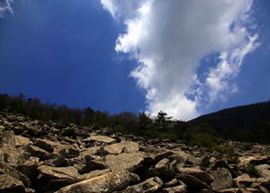
Introduction The geopark is located in the precinct of Xi’an city, Shaanxi Province, 25km far away from Xi’an. It covers an area of 1074.85 km2 and is regarded as “Chinese Central National Park”, in which the Qinling orogenic belt, the Quaternary geological heritages, geomorphological sites and the relics of palaeoanthropology are the major attractions. Qinling Zhongnanshan UNESCO Geopark is validated to join in GGN by UNESCO in August 2009, and it is the first Global Geopark in the northwest area. Cuihuashan, Nanwutai, Heihe, Taiping, Lishan, Zhuque and Wangshunshan scenic areas and Lantian Ape Man site are in Northern of Qinling as eight pearls in silk belt. |
 |
|
Qinling Zhongnanshan Geopark is validated to join in GGN by UNESCO in August 2009, and it is named Qinling Zhongnanshan Global Geopark. Qinling Zhongnanshan Global Geopark passed the revalidation in July 2013, and it continues to be a member of GGN. GGN joined in UNESCO IGGP in November, 2015, and Qinling Zhongnanshan Global Geopark is named Qinling Zhongnanshan UNESCO Global Geopark.Cuihuashan, Nanwutai, Heihe, Taiping, Lishan, Zhuque and Wangshunshan scenic areas and Lantian Ape Man site are in Northern of Qinling as eight pearls in silk belt. |
 |
|
Climate, ecology & historical culture
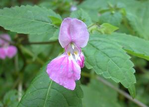
Qinling Zhongnanshan UNESCO Global Geopark has a warmly sub humid monsoon climate with clear distinction in four seasons, and 226 days of frost-free period, averaged 0.4℃ in January, 26.6℃ in July and 13.3℃ in a year round. Annual precipitation in the area averages 613.7mm and average humidity 69.6%. Climate in the mountainous terrain has showed an evident vertical donation, 100m risen to 0.6℃ fallen. The geopark is abundant in water resources of 40×108m3, and it is 51% of the central of Shaanxi plain. There are 28 rivers including the Heihe River, the Laohe River, the Fenghe River etc. and 30 water reservoirs in the geopark. The southern of Zhongnanshan is north subtropical zone humid region, and the north is warm temperature semi-humid region. Besides, the northern slope is a mixed area of coniferous forest, broadleaf and deciduous broadleaf forest of warm temperature zone, the north boundary of evergreen broadleaf trees and subtropical plants in China, a conjunct area of northern China, central China, Tanggute and Hengduan Mountain. Floras and faunas are transitional, mixed and varied in this area. The vertically biological zoning in integrity makes the area an important biological gene base. The area is also important for a number of rare animals, such as panda, golden monkey, Qinlingtakin, crested ibis etc, and rare plants such as kingdonia uniflora etc.
|
 |
|
The particular geological backgrounds formed the highest mountain peak in the east of China, and the rich Weihe basin.
Ancient humans lived at bottom of Zhongnanshan in the Paleolithic Period
where Chinese civilization, poem, garden are originated, besides, it’s a
special area of nature and human harmonious coexistence. It presents the remains of the Lantian Homo erectus,
Shangyu Old Road (about 600 km from Shangzhou to Henan Province), the Ziwu
Plank Road (about 330 km from Chang’an District to Xixiang County), temples of
different religions, gardens of Zhou (dated 1122-221B.C), Qin(221-206B.C.),
Han(206B.C.-220A.D.) and Tang (618A.D.-907A.D.) dynasties, the famous Lantian
jade in ancient times and the other 12 national important cultural relics
protection departments.
|
 |
![]()
![]()
![]()
![]()
![]()
![]()
![]()
![]()
![]()
![]()
地址:西安市劳动南路178号资源规划服务大厦 电话:(029)84266238
陕ICP备12012040号-2秦岭终南山世界地质公园版权所有
Copyright © 2012 Qinling Zhongnanshan Geopark All Rights Reserved.51.La [后台管理]